Cochrane & Lochend Areas Ramble
Date/Time
1 Jan 1970
Location
Cochrane Ranche
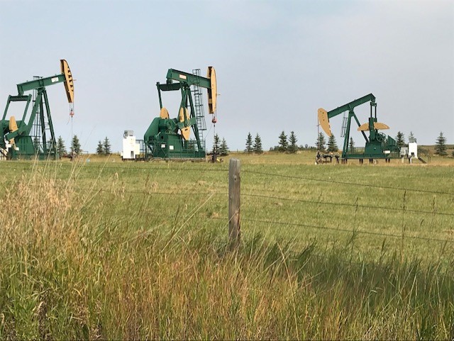
This Friday afternoon adventure, which begins in Cochrane, is a road trip where we will see various forms of magnificent glacial geology in the Cochrane & Lochend areas and also see a rapidly developing program of hydraulic fracking for oil in the Lochend area. We will drive through and stop at locations in the deeply incised glacial melt water channel which runs from Cochrane to Big Hill Springs Provincial Park and onwards into the southeast Lochend area. A similar melt water channel also occurs just south of the small village of Dog Pound. We will also see areas covered by glacial moraines characterized by knob & kettle topography and glacial drumlins. Small creeks and ponds occur in these channels and provide habitat for abundant water fowl. We will stop and discuss the numerous oil well pads along the north side of Highway 567, and also along the east and west sides of Lochend Road, which produce oil from the tight Cardium sandstone oil play. Long distance horizontal wells combined with hydraulic fracking have led to the success of this oil program. Drilling and oil production is now occurring from near to the northern boundaries of Cochrane, eastwards to Highway 766 (also known as Lochend Road), northwards to Highway 574 and westwards to Highway 22 (also known as the Cowboy Trail). The total area covered by this activity amounts to approximately 200 square kilometers and in some cases has had significant environmental impact on ranches, farms and acreages in the area.
Coordinator
Tako KoningSenior Petroleum Geologist
Photos and Report
Fundraising Goal
Why Join This Adventure?
Adventure Metrics
Required Equipment
Covid-19 Precautions
Details
Contact this Coordinator
[addtoany url="https://www.adventuresforwilderness.ca/adventures/a4w2020-cochrane-lochend-areas-ramble/" title="There's a great wilderness adventure happening in Alberta this year! Cochrane & Lochend Areas Ramble:" buttons="facebook,twitter,email" media="https://www.adventuresforwilderness.ca/wp-content/uploads/2020/09/a4w2020_cochrane_lochend_tkoning.jpg"]
